FIRST with real time Breaking News coverage overnight
Creative Commons License
Operation 100 News by Operation 100 News - Mike Frizzell is licensed under a Creative Commons Attribution-NonCommercial-NoDerivs 3.0 Unported License.
Posted material may not be copied, rewritten, published, broadcast, or otherwise shared without proper attribution given, including link to original webpage.
Contact Mike Frizzell -
Operation100news@gmail.com
Showing posts with label Severe Weather. Show all posts

Monday, May 7, 2012

Severe weather strikes Douglas & Johnson counties Sunday

Posted: May 7, 2012 - 5:50am
Update: May 7, 2012 - 6:07am

This morning, the National Weather Service says two tornadoes briefly touched down in Olathe on Sunday evening.

The first touchdown was reported at 6:10 p.m., near Kansas 7 Highway (K-7) and Santa Fe Street by a Trained Weather Spotter.

About 10 minutes later, another touchdown was, reported at 6:22 p.m., near Interstate 35 and United States Highway 169 (US-169) by Olathe Fire Department personnel. See the YouTube video at the bottom of this post for audio of this report.

Weather Spotters and Law Enforcement also reported rotation and lowering in the area of K-7 south of 119th Street and to the southwest of the K-7 and K-10 interchange. This lowering was not reported to have made contact with the ground.

No injuries or damage were reported directly related to the brief tornado touchdowns.

Severe Weather Reports to the National Weather Service
Hail was also reported just outside of Eudora and in Lawrence. Hail reports in Douglas County varied from Dime to Half Dollar in size. Minor damage was reported to a few vehicles in Douglas County as a result of the hail.

Several hundred were without power for times in both Douglas and Johnson Counties. Westar Energy reported nearly 600 Douglas County customers without power around 6:30 p.m..

Here is a rare glimpse behind the scenes of what was going on here at Operation 100 News as the second touchdown was being reported in Olathe. This recording includes audio from four scanners, with audio from Law Enforcement, Fire Department, and Weather Spotters. Some of the audio is difficult to understand as scanner volumes varied and the camera was closer to the Law Enforcement scanner than it was to the Spotter and Fire Department scanners. 


As always, Operation 100 News is the work of one person. Therefore I may not always be available to provide you with weather updates when severe weather is headed for your neighborhood. Please do not rely solely on one source for emergency weather information. A NOAA Weather Radio is a great option to have handy. More Information here

Attention News Media LINK

All comments on posted content are moderated. Inappropriate and/or abusive comments will not be published. More information.

Saturday, April 14, 2012

Weather: HIGH RISK of severe storms today

Posted: April 14, 2012 - 6:13am
Updated: April 14, 2012 - 4:20pm

The Storm Prediction Center (SPC) in Norman, Oklahoma has stuck with their earlier prediction of "Life-Threatening High Risk" of severe weather for Saturday.

SPC forecast for severe weather potential Saturday, April 14, 2012
Click map to view larger
The highest risk area for severe weather today is across most of central and eastern Nebraska, parts of north central Kansas and western Iowa. There is also a high risk for later this afternoon and evening for parts of south central Kansas and north central Oklahoma.

Areas included in the "Moderate Risk" include the remainder of central and eastern Nebraska, western Iowa, northwestern Missouri, central and eastern Kansas, along with parts of northern and central Oklahoma.

A slight risk area includes a large portion of the central and southern plains, from Texas north to southern parts of Minnesota and South Dakota.

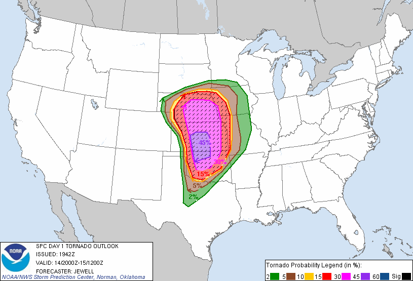
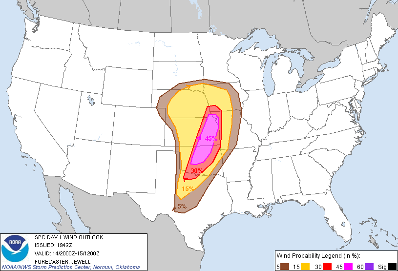
Maps: Areas within the black hatching are considered the most likely areas for the activity to occur.

SPC forecast of tornado potential Saturday, April 14, 2012
Click map to view larger
SPC forecast of damaging wind potential Saturday, April 14, 2012
Click map to view larger
SPC forecast of hail potential Saturday, April 14, 2012
Click map to view larger
The SPC predicts that weather conditions should be favorable for "supporting long-lived supercells capable of producing strong tornadoes" for areas of Kansas, Oklahoma and stretching into north central and northwestern Texas. Forecasters also warn of the potential for strong wind gusts in excess of 70 miles per hour and very large hail of 2 inches in diameter or greater.


Anyone living within this region should insure that they have a way to receive severe weather warnings late Saturday afternoon and into the overnight hours, including while they are asleep. Please do not rely solely on outdoor warning sirens. 


Remember to charge cell phones in advance of the storm. After the storm remember that using text messaging and social media is much easier on wireless (cell phone) networks. Wireless calling consumes more bandwidth than text messaging. Using a wireless call for a non-emergency conversation may be enough to keep someone who needs emergency assistance from easily accessing 911 to get the help they need. If you are not in immediate danger please consider using text messaging or social media to inform family and friends that you are safe. 

Those located within the predicted areas are encouraged to stay tuned to local media and/or NOAA Weather Radios and have a safety plan in place as this is a potentially deadly situation.

Outdoor warning sirens are intended to provide tornado warnings only for those who are outdoors. Outdoor sirens may not wake you in the night and alert you of approaching severe weather. A NOAA Weather Radio can alert you to severe storms. NOAA Weather Radios are received from the National Weather Service 24 hours a day, seven days a week. The Metropolitan Emergency Managers Committee (MEMC) partnered with Midland Radio and Price Chopper, launched Project Community Alert (PCA) in 2002, to offer NOAA All-Hazard Weather Radio Receivers to the public at-cost. More information on NOAA Weather Radios and Project Community Alert.


NOAA All-Hazards Weather Radio Stations throughout Kansas
Click to view full size
Outdoor Warning Siren locations and coverage areas in Johnson County
Click to view full size
View a map of Douglas County, Kansas' outdoor warning siren locations here. Map will open a new window in PDF format.


All information provided by the Storm Prediction Center (Norman, Oklahoma), the National Weather Service offices (Pleasant Hill, Missouri and Topeka, Kansas), the Kansas Division of Emergency Management (Topeka, Kansas), Johnson County Emergency Management (Olathe, Kansas), and Douglas County Emergency Management (Lawrence, Kansas)

Attention News Media LINK

All comments on posted content are moderated. Inappropriate and/or abusive comments will not be published.
More information

Friday, April 13, 2012

Weather: Violent tornado outbreak likely this weekend

Posted: April 13, 2012 - 3:43am
Updated: April 13, 2012 - 4:18am

This is not something that I normally report on but, I believe this is going to be significant enough that an early heads up will be useful.

The Storm Prediction Center (SPC) in Norman, Oklahoma has issued a "High Risk" of severe weather for their Day 2 (Saturday) forecast period. This is an extremely rare occurrence for the SPC to issue a "High Risk" in a Day 2 forecast.

Maps:
SPC forecast for Severe Weather potential Saturday, April 14, 2012
Click map to view full size
SPC forecast probability outlook for Saturday, April 14, 2012
Click map to view full size
Anyone living within the black hatched areas, of the second map, should expect severe weather Saturday evening into early Sunday morning.

The SPC warns of the potential for; very large hail of 2 inches in diameter or greater, strong wind gusts in excess of 70 miles per hour, and potentially long track tornadoes. This includes areas of Kansas, Missouri, Nebraska, Oklahoma, and Texas. The highest risk areas are expected to be along Interstate 35 from Oklahoma City, Oklahoma extending north to near Salina, Kansas. Wichita, Kansas is also within the highest risk area. Areas of Kansas between Salina and Kansas City should be prepared for the approaching storms. This includes Lawrence, Emporia, Ottawa, and the Kansas City area.

Storms are expected to begin in the area by late afternoon Saturday and last through the evening and overnight hours as they move East/Northeast. The storms are expected to maintain their severe potential after dark, making this storm especially dangerous.

Anyone living within this region should insure that they have a way to receive severe weather warnings late Saturday afternoon and into the overnight hours, including while they are asleep. Please do not rely solely on outdoor warning sirens. 

Those located within the predicted areas are encouraged to stay tuned to local media and have a safety plan in place as this is a potentially deadly situation.

Outdoor warning sirens are intended to provide tornado warnings only for those who are outdoors. Outdoor sirens may not wake you in the night and alert you of approaching severe weather. A NOAA Weather Radio can alert you to severe storms. NOAA Weather Radios are received from the National Weather Service 24 hours a day, seven days a week. The Metropolitan Emergency Managers Committee (MEMC) partnered with Midland Radio and Price Chopper, launched Project Community Alert (PCA) in 2002, to offer NOAA All-Hazard Weather Radio Receivers to the public at-cost. More information on NOAA Weather Radios and Project Community Alert.


NOAA All-Hazards Weather Radio Stations throughout Kansas
Click to view full size
Outdoor Warning Siren locations and coverage areas in Johnson County
Click to view full size

All information provided by the Storm Prediction Center in Norman, Oklahoma, the National Weather Service office in Pleasant Hill, Missouri and the Kansas Division of Emergency Management.

Attention News Media LINK

All comments on posted content are moderated. Inappropriate and/or abusive comments will not be published.
More information

Monday, March 12, 2012

Severe Weather Awareness Week 2012

Posted: March 12, 2012 - 3:40am
Updated: March 13, 2012 - 7:00am

In 2011 there were 68 tornadoes in Kansas, three people were killed and seven others injured. The first tornado  of the 2011 season was an EF0 on February 27th in Cowley county and the last of the year was and EF1 on October 8th in Haskell county.


March 12-16, 2012 is this year's Severe Weather Awareness Week in Kansas, conducted by the Kansas Division of Emergency Management and local emergency management agencies throughout the state. The National Weather Service says, the 2012 severe weather season has already become quite active across the country so it is imperative you prepare now. Severe Weather Awareness Week is a week when the public is encouraged to review their severe weather safety plans.

  • Monday, March 12th is "Preparedness Day." The National Weather Service suggest three simple steps to complete. First, Identify the severe weather hazards you may face. Second, Set up your plan. Third, Practice your plan. More information on these three steps
  • Tuesday, March 13th is "Tornadoes Day." Emergency Management agencies throughout Kansas will be taking part in a Tornado Safety Drill at 1:30 p.m. local time. Outdoor warning sirens will sound and the public, including schools and businesses, are encouraged to put their tornado safety plans into action as if there was a tornado warning issued. More information on Tornado Safety.
  • Wednesday, March 14th is "Flash Flood Day." In the past 10 years, flooding has accounted for 14 deaths and $41 million in damages in Kansas alone. "Turn around, Don't Drown!" More information on Flood Safety.
  • Thursday, March 15th is "Thunderstorm Day." All severe thunderstorms have the potential to produce damaging winds and large hail. Winds and hail can and do severely damage property every year in Kansas. More information on Hail and Damaging Winds.
  • Friday, March 16th is "NOAA Weather Radio Day." Outdoor warning sirens are intended to provide tornado warnings only for those who are outdoors. Outdoor sirens may not wake you in the night and alert you of approaching severe weather. A NOAA Weather Radio can alert you to severe storms. NOAA Weather Radios are received from the National Weather Service 24 hours a day, seven days a week. The Metropolitan Emergency Managers Committee (MEMC) partnered with Midland Radio and Price Chopper, launched Project Community Alert (PCA) in 2002, to offer NOAA All-Hazard Weather Radio Receivers to the public at-cost. More information on NOAA Weather Radios and Project Community Alert.
2011 Tornadoes by county
Click to view full size

NOAA All-Hazards Weather Radio Stations throughout Kansas
Click to view full size
Outdoor Warning Siren locations and coverage areas in Johnson County
Click to view full size


All information provided by the Kansas Division of Emergency Management, Kansas Emergency Management Association, National Weather Service office in Pleasant Hill, Missouri. 2012 Severe Weather Awareness packet

Attention News Media LINK

All comments on posted content are moderated. Inappropriate and/or abusive comments will not be published.
More information