FIRST with real time Breaking News coverage overnight
Creative Commons License
Operation 100 News by Operation 100 News - Mike Frizzell is licensed under a Creative Commons Attribution-NonCommercial-NoDerivs 3.0 Unported License.
Posted material may not be copied, rewritten, published, broadcast, or otherwise shared without proper attribution given, including link to original webpage.
Contact Mike Frizzell -
Operation100news@gmail.com
Showing posts with label Weather. Show all posts

Saturday, April 14, 2012

Weather: HIGH RISK of severe storms today

Posted: April 14, 2012 - 6:13am
Updated: April 14, 2012 - 4:20pm

The Storm Prediction Center (SPC) in Norman, Oklahoma has stuck with their earlier prediction of "Life-Threatening High Risk" of severe weather for Saturday.

SPC forecast for severe weather potential Saturday, April 14, 2012
Click map to view larger
The highest risk area for severe weather today is across most of central and eastern Nebraska, parts of north central Kansas and western Iowa. There is also a high risk for later this afternoon and evening for parts of south central Kansas and north central Oklahoma.

Areas included in the "Moderate Risk" include the remainder of central and eastern Nebraska, western Iowa, northwestern Missouri, central and eastern Kansas, along with parts of northern and central Oklahoma.

A slight risk area includes a large portion of the central and southern plains, from Texas north to southern parts of Minnesota and South Dakota.

Maps: Areas within the black hatching are considered the most likely areas for the activity to occur.
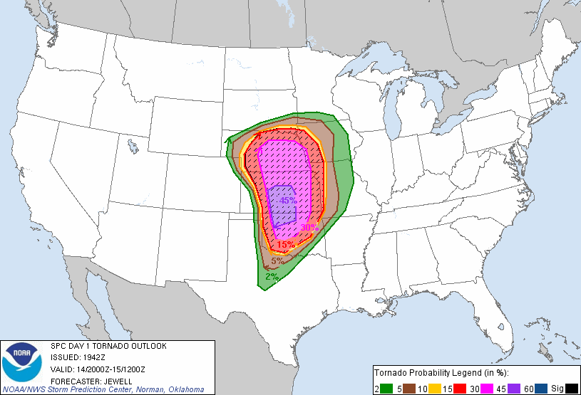
SPC forecast of tornado potential Saturday, April 14, 2012
Click map to view larger
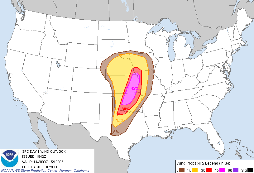
SPC forecast of damaging wind potential Saturday, April 14, 2012
Click map to view larger
SPC forecast of hail potential Saturday, April 14, 2012
Click map to view larger
The SPC predicts that weather conditions should be favorable for "supporting long-lived supercells capable of producing strong tornadoes" for areas of Kansas, Oklahoma and stretching into north central and northwestern Texas. Forecasters also warn of the potential for strong wind gusts in excess of 70 miles per hour and very large hail of 2 inches in diameter or greater.


Anyone living within this region should insure that they have a way to receive severe weather warnings late Saturday afternoon and into the overnight hours, including while they are asleep. Please do not rely solely on outdoor warning sirens. 


Remember to charge cell phones in advance of the storm. After the storm remember that using text messaging and social media is much easier on wireless (cell phone) networks. Wireless calling consumes more bandwidth than text messaging. Using a wireless call for a non-emergency conversation may be enough to keep someone who needs emergency assistance from easily accessing 911 to get the help they need. If you are not in immediate danger please consider using text messaging or social media to inform family and friends that you are safe. 

Those located within the predicted areas are encouraged to stay tuned to local media and/or NOAA Weather Radios and have a safety plan in place as this is a potentially deadly situation.

Outdoor warning sirens are intended to provide tornado warnings only for those who are outdoors. Outdoor sirens may not wake you in the night and alert you of approaching severe weather. A NOAA Weather Radio can alert you to severe storms. NOAA Weather Radios are received from the National Weather Service 24 hours a day, seven days a week. The Metropolitan Emergency Managers Committee (MEMC) partnered with Midland Radio and Price Chopper, launched Project Community Alert (PCA) in 2002, to offer NOAA All-Hazard Weather Radio Receivers to the public at-cost. More information on NOAA Weather Radios and Project Community Alert.


NOAA All-Hazards Weather Radio Stations throughout Kansas
Click to view full size
Outdoor Warning Siren locations and coverage areas in Johnson County
Click to view full size
View a map of Douglas County, Kansas' outdoor warning siren locations here. Map will open a new window in PDF format.


All information provided by the Storm Prediction Center (Norman, Oklahoma), the National Weather Service offices (Pleasant Hill, Missouri and Topeka, Kansas), the Kansas Division of Emergency Management (Topeka, Kansas), Johnson County Emergency Management (Olathe, Kansas), and Douglas County Emergency Management (Lawrence, Kansas)

Attention News Media LINK

All comments on posted content are moderated. Inappropriate and/or abusive comments will not be published.
More information

Friday, April 13, 2012

Weather: Violent tornado outbreak likely this weekend

Posted: April 13, 2012 - 3:43am
Updated: April 13, 2012 - 4:18am

This is not something that I normally report on but, I believe this is going to be significant enough that an early heads up will be useful.

The Storm Prediction Center (SPC) in Norman, Oklahoma has issued a "High Risk" of severe weather for their Day 2 (Saturday) forecast period. This is an extremely rare occurrence for the SPC to issue a "High Risk" in a Day 2 forecast.

Maps:
SPC forecast for Severe Weather potential Saturday, April 14, 2012
Click map to view full size
SPC forecast probability outlook for Saturday, April 14, 2012
Click map to view full size
Anyone living within the black hatched areas, of the second map, should expect severe weather Saturday evening into early Sunday morning.

The SPC warns of the potential for; very large hail of 2 inches in diameter or greater, strong wind gusts in excess of 70 miles per hour, and potentially long track tornadoes. This includes areas of Kansas, Missouri, Nebraska, Oklahoma, and Texas. The highest risk areas are expected to be along Interstate 35 from Oklahoma City, Oklahoma extending north to near Salina, Kansas. Wichita, Kansas is also within the highest risk area. Areas of Kansas between Salina and Kansas City should be prepared for the approaching storms. This includes Lawrence, Emporia, Ottawa, and the Kansas City area.

Storms are expected to begin in the area by late afternoon Saturday and last through the evening and overnight hours as they move East/Northeast. The storms are expected to maintain their severe potential after dark, making this storm especially dangerous.

Anyone living within this region should insure that they have a way to receive severe weather warnings late Saturday afternoon and into the overnight hours, including while they are asleep. Please do not rely solely on outdoor warning sirens. 

Those located within the predicted areas are encouraged to stay tuned to local media and have a safety plan in place as this is a potentially deadly situation.

Outdoor warning sirens are intended to provide tornado warnings only for those who are outdoors. Outdoor sirens may not wake you in the night and alert you of approaching severe weather. A NOAA Weather Radio can alert you to severe storms. NOAA Weather Radios are received from the National Weather Service 24 hours a day, seven days a week. The Metropolitan Emergency Managers Committee (MEMC) partnered with Midland Radio and Price Chopper, launched Project Community Alert (PCA) in 2002, to offer NOAA All-Hazard Weather Radio Receivers to the public at-cost. More information on NOAA Weather Radios and Project Community Alert.


NOAA All-Hazards Weather Radio Stations throughout Kansas
Click to view full size
Outdoor Warning Siren locations and coverage areas in Johnson County
Click to view full size

All information provided by the Storm Prediction Center in Norman, Oklahoma, the National Weather Service office in Pleasant Hill, Missouri and the Kansas Division of Emergency Management.

Attention News Media LINK

All comments on posted content are moderated. Inappropriate and/or abusive comments will not be published.
More information

Monday, December 19, 2011

DgCo Weather: Winter WX Advisory issued

Posted: December 19, 2011 - 4:40am
Updated: December 20, 2011 - 4:16pm

CANCELLED: December 20, 4:15 a.m. More information on cancellation.

The National Weather Service in Topeka has issued a Winter Weather Advisory for wintry precipitation. The Advisory will go into effect at 12:00 a.m. Tuesday morning and remain in place until 6:00 p.m. Tuesday evening. The previous Winter Storm Watch has been canceled.

The advisory area includes the Kansas counties of Douglas, Lyon and Osage. Cities include; Lawrence and Emporia.

Click map to view larger
Forecasters now say that rain will begin to develop Monday morning and transition to snow late Monday evening into Tuesday. Total snow accumulations of one to three inches is expected in the advisory area. Periods of light sleet and freezing drizzle are also expected overnight into Tuesday morning. Winds are expected to be from the north to northeast and 15 to 25 miles per hour with gusts to around 35 miles per hour.

Hazardous driving conditions from snowfall and ice accumulations as well as reduced visibilities are also possible, according to the National Weather Service in Topeka.

Click to view image full size
Released: December 19,  10:48 a.m.


Click image to view full size
Released: December 19, 4:35 a.m.
More from the City of Lawrence can be found here.

Attention News Media LINK

Sunday, December 18, 2011

Winter Weather Watch, Douglas County, CANCELED

Posted: December 18, 2011 - 4:30am
Updated: December 19, 2011 - 4:35am

The National Weather Service in Topeka has CANCELED the Winter Weather Watch. The watch area did include the city of Lawrence and all of Douglas County.

The watch goes into effect Monday, December 19th at 6:00 p.m., and will remain in place until Tuesday, December 20th at 6:00 p.m..

Shaded area is under the watch
Click image to view larger
Forecasters say that rain and snow are expected to develop Monday and transition to snow Monday evening into Tuesday. Accumulating snow is expected to end by late Tuesday afternoon.

Total snow and ice accumulations are possible in the range of four to eight inches. Light accumulations of sleet and freezing drizzle may also occur.

Winds are expected to be between 15 and 20 miles per hour with gusts to 30 miles per hour.

Drivers should expect possibly hazardous driving conditions due to heavy snowfall and ice accumulations and reduced visibilities.

View more on this Watch from the National Weather Service office in Topeka, Kansas.

Attention News Media LINK