Updated: April 14, 2012 - 4:20pm
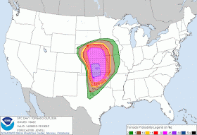
The Storm Prediction Center (SPC) in Norman, Oklahoma has stuck with their earlier prediction of "Life-Threatening High Risk" of severe weather for Saturday.
 |
| SPC forecast for severe weather potential Saturday, April 14, 2012 Click map to view larger |
Areas included in the "Moderate Risk" include the remainder of central and eastern Nebraska, western Iowa, northwestern Missouri, central and eastern Kansas, along with parts of northern and central Oklahoma.
A slight risk area includes a large portion of the central and southern plains, from Texas north to southern parts of Minnesota and South Dakota.
Maps: Areas within the black hatching are considered the most likely areas for the activity to occur.
 |
| SPC forecast of tornado potential Saturday, April 14, 2012 Click map to view larger |
 |
| SPC forecast of damaging wind potential Saturday, April 14, 2012 Click map to view larger |
 |
| SPC forecast of hail potential Saturday, April 14, 2012 Click map to view larger |
Anyone living within this region should insure that they have a way to receive severe weather warnings late Saturday afternoon and into the overnight hours, including while they are asleep. Please do not rely solely on outdoor warning sirens.
Remember to charge cell phones in advance of the storm. After the storm remember that using text messaging and social media is much easier on wireless (cell phone) networks. Wireless calling consumes more bandwidth than text messaging. Using a wireless call for a non-emergency conversation may be enough to keep someone who needs emergency assistance from easily accessing 911 to get the help they need. If you are not in immediate danger please consider using text messaging or social media to inform family and friends that you are safe.
Remember to charge cell phones in advance of the storm. After the storm remember that using text messaging and social media is much easier on wireless (cell phone) networks. Wireless calling consumes more bandwidth than text messaging. Using a wireless call for a non-emergency conversation may be enough to keep someone who needs emergency assistance from easily accessing 911 to get the help they need. If you are not in immediate danger please consider using text messaging or social media to inform family and friends that you are safe.
Those located within the predicted areas are encouraged to stay tuned to local media and/or NOAA Weather Radios and have a safety plan in place as this is a potentially deadly situation.
Outdoor warning sirens are intended to provide tornado warnings only for those who are outdoors. Outdoor sirens may not wake you in the night and alert you of approaching severe weather. A NOAA Weather Radio can alert you to severe storms. NOAA Weather Radios are received from the National Weather Service 24 hours a day, seven days a week. The Metropolitan Emergency Managers Committee (MEMC) partnered with Midland Radio and Price Chopper, launched Project Community Alert (PCA) in 2002, to offer NOAA All-Hazard Weather Radio Receivers to the public at-cost. More information on NOAA Weather Radios and Project Community Alert.
More information on Tornado Safety can be found here from the National Weather Service.
More information on Severe Weather from the 2012 Severe Weather Awareness packet .
 |
| NOAA All-Hazards Weather Radio Stations throughout Kansas Click to view full size |
 |
| Outdoor Warning Siren locations and coverage areas in Johnson County Click to view full size |
View a map of Douglas County, Kansas' outdoor warning siren locations here. Map will open a new window in PDF format.
All information provided by the Storm Prediction Center (Norman, Oklahoma), the National Weather Service offices (Pleasant Hill, Missouri and Topeka, Kansas), the Kansas Division of Emergency Management (Topeka, Kansas), Johnson County Emergency Management (Olathe, Kansas), and Douglas County Emergency Management (Lawrence, Kansas)
Attention News Media LINK
All comments on posted content are moderated. Inappropriate and/or abusive comments will not be published.
More information
All comments on posted content are moderated. Inappropriate and/or abusive comments will not be published.
More information

No comments :
Post a Comment