Updated: April 27, 2012 - 3:25pm
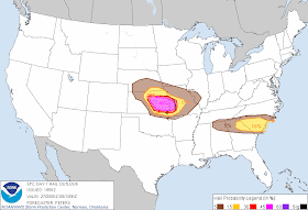
The National Weather Service's Storm Prediction Center (SPC) in Norman, Oklahoma has upgraded their prediction for severe weather in central and eastern Kansas today.
As a surface low moves across Kansas, strong southerly winds are expected. These winds will help a warm front move northward into eastern Kansas. These factors contribute to the now increased "Moderate" risk of severe thunderstorms and tornadoes late this afternoon into this evening.
The main threat for the Kansas City and Lawrence area still appears to be large hail, possibly as large as golf ball sized. Douglas County has been placed under at Tornado Watch until 9 p.m..
 |
| Categorical outlook Click map to view larger |
 |
| Tornado outlook Click map to view larger |
 |
| Wind outlook Click map to view larger |
 |
| Hail outlook Click map to view larger |
All information provided by the Storm Prediction Center (Norman, Oklahoma), and the National Weather Service offices (Pleasant Hill, Missouri and Topeka, Kansas).
Attention News Media LINK
All comments on posted content are moderated. Inappropriate and/or abusive comments will not be published.
More information
All comments on posted content are moderated. Inappropriate and/or abusive comments will not be published.
More information

No comments :
Post a Comment